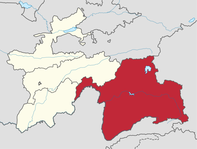
File:Gorno-Badakhshan Autonomous Province in Tajikistan.svg

Original file (SVG file, nominally 1,191 × 903 pixels, file size: 267 KB)
Captions
Captions
Summary[edit]

|
This file requires updating. In doing so, you could add a timestamp to the file.
|
Licensing[edit]

|
Permission is granted to copy, distribute and/or modify this document under the terms of the GNU Free Documentation License, Version 1.2 or any later version published by the Free Software Foundation; with no Invariant Sections, no Front-Cover Texts, and no Back-Cover Texts. A copy of the license is included in the section entitled GNU Free Documentation License.http://www.gnu.org/copyleft/fdl.htmlGFDLGNU Free Documentation Licensetruetrue |
- You are free:
- to share – to copy, distribute and transmit the work
- to remix – to adapt the work
- Under the following conditions:
- attribution – You must give appropriate credit, provide a link to the license, and indicate if changes were made. You may do so in any reasonable manner, but not in any way that suggests the licensor endorses you or your use.
- share alike – If you remix, transform, or build upon the material, you must distribute your contributions under the same or compatible license as the original.

|
I'd greatly appreciate, that you attribute this media file to Wikimedia Commons, if used outside Wikipedia or Commons. For use in publications such as books, newspapers, blogs, websites, please insert here the following line:
বাংলা ∙ Deutsch ∙ Deutsch (Sie-Form) ∙ Ελληνικά ∙ English ∙ español ∙ français ∙ Ἀρχαία ἑλληνικὴ ∙ Bahasa Indonesia ∙ 日本語 ∙ македонски ∙ Nederlands ∙ português ∙ русский ∙ Türkçe ∙ 简体中文 ∙ 繁體中文 ∙ +/− |
File history
Click on a date/time to view the file as it appeared at that time.
| Date/Time | Thumbnail | Dimensions | User | Comment | |
|---|---|---|---|---|---|
| current | 07:51, 23 October 2013 |  | 1,191 × 903 (267 KB) | TUBS (talk | contribs) | |
| 15:07, 15 September 2011 |  | 1,191 × 905 (483 KB) | TUBS (talk | contribs) |
You cannot overwrite this file.
File usage on Commons
The following 8 pages use this file:
- Atlas of Gorno-Badakhshan
- Pamir Mountains
- File:Badakhshan.svg
- File:Tj4-kaart.png
- Category:Districts of Gorno-Badakhshan Autonomous Province
- Category:Gorno-Badakhshan Autonomous Province
- Category:Populated places in Gorno-Badakhshan Autonomous Province
- Category:Rivers of Gorno-Badakhshan Autonomous Province
File usage on other wikis
The following other wikis use this file:
- Usage on ar.wikipedia.org
- Usage on az.wikipedia.org
- Usage on be-tarask.wikipedia.org
- Usage on be.wikipedia.org
- Usage on bg.wikipedia.org
- Usage on bn.wikipedia.org
- Usage on ca.wikipedia.org
- Usage on cs.wikipedia.org
- Usage on de.wikipedia.org
- Usage on en.wikipedia.org
- Badakhshan
- Khorog
- Gorno-Badakhshan
- Murghob
- Gunt
- Bartang
- Yazghulom
- Vanj
- Vanj (river)
- Territorial evolution of Russia
- Qal'ai Khumb
- Vanj District
- Template:Gorno-Badakhshan
- Darvoz District
- Ishkoshim District
- Murghob District
- Roshtqal'a District
- Rushon District
- Shughnon District
- Tavildara
- Rushon
- Mayakovsky Peak
- Shakhdara Range
- Yazgulem Range
- Karl Marx Peak
- Rushan Range
- Salient (geography)
- Vanj Range
- Ishkoshim, Tajikistan
- Ishkoshim Range
- Gharm-Chashma
- Sarikol Range
- Porshinev
- 2012 Gorno-Badakhshan clashes
- Insurgency in Gorno-Badakhshan (2010–2015)
- Roshtqal'a
- Vahdat, Gorno-Badakhshan
- Darvoz Range
View more global usage of this file.
Metadata
This file contains additional information such as Exif metadata which may have been added by the digital camera, scanner, or software program used to create or digitize it. If the file has been modified from its original state, some details such as the timestamp may not fully reflect those of the original file. The timestamp is only as accurate as the clock in the camera, and it may be completely wrong.
| Width | 1190.574px |
|---|---|
| Height | 902.822px |
.svg/55px-Africa_on_the_globe_(red).svg.png)
.svg/55px-Asia_on_the_globe_(red).svg.png)
.svg/55px-Europe_on_the_globe_(red).svg.png)
.svg/55px-North_America_on_the_globe_(red).svg.png)
.svg/55px-Oceania_on_the_globe_(red).svg.png)
.svg/55px-South_America_on_the_globe_(red).svg.png)
.svg/55px-Antarctica_on_the_globe_(red).svg.png)

-en.svg/120px-Toolbox_SVG_locator_maps_(location_map_based)-en.svg.png)

.svg/120px-Texas_in_United_States_(US48).svg.png)
.svg/120px-Poland_in_European_Union_(-rivers_-mini_map).svg.png)
.svg/120px-Russia_on_the_globe_(Russia_centered).svg.png)

_(US48).svg/120px-Rhode_Island_in_United_States_(special_marker)_(US48).svg.png)
_(small_islands_magnified)_(-mini_map_-rivers).svg/120px-France_in_Oceania_(French_Polynesia_special)_(small_islands_magnified)_(-mini_map_-rivers).svg.png)
.svg/120px-Milne_Bay_in_Papua_New_Guinea_(special_marker).svg.png)
_(extra_close)_(US48).svg/120px-Rhode_Island_in_United_States_(zoom)_(extra_close)_(US48).svg.png)
.svg/120px-Acklins_in_Bahamas_(zoom).svg.png)
_(zoom).svg/120px-Département_971_in_France_(-mini_map)_(zoom).svg.png)

.svg/120px-St_Peter_Port_in_Guernsey_(zoom).svg.png)


_(UNMIK).svg/84px-Pec_in_Serbia_(Kosovo_semi-independent)_(UNMIK).svg.png)
.svg/120px-Serbia_in_its_region_(claimed_hatched).svg.png)
_(disputed_hatched).svg/120px-Mtskheta-Mtianeti_in_Georgia_(semi-secession)_(disputed_hatched).svg.png)
_(claimed_and_disputed_hatched).svg/111px-Jammu_and_Kashmir_in_India_(de-facto_+claimed_hatched)_(claimed_and_disputed_hatched).svg.png)
.svg/120px-Morocco_in_its_region_(disputed_hatched).svg.png)
.svg/120px-Morocco_in_its_region_(de-facto_and_disputed_hatched).svg.png)
_(+all_claims_hatched).svg/120px-Taiwan_in_China_(claimed_hatched)_(+all_claims_hatched).svg.png)

.svg/101px-City_of_San_Marino_in_San_Marino_(+pop_areas).svg.png)
_(shade).svg/101px-Lower_Saxony_in_Germany_(relief)_(shade).svg.png)
_(shade)_(special_marker).svg/101px-Lower_Saxony_in_Germany_(relief)_(shade)_(special_marker).svg.png)
_(-mini_map).svg/120px-Germany_in_Europe_(blue_marble)_(-mini_map).svg.png)
_(-mini_map).svg/120px-Sweden_in_Europe_(natural)_(-mini_map).svg.png)
_(-mini_map).svg/120px-Samoa_in_Oceania_(relief)_(-mini_map).svg.png)


.svg/55px-Antarctica%2C_administrative_divisions_-_de_-_colored_(explicit).svg.png)

.svg/55px-Afro-Eurasia_on_the_globe_(yellow).svg.png)